PRELIMINARY RESULTS BASED ON SEISMOLOGICAL AND GEODETIC OBSERVATIONS PUBLISHED BY RESEARCHERS FROM UNIVERSITIES AND LABORATORIES AROUND THE WORLD.
At 14:46 (Local Time) 03/11/2011, an earthquake of 9.0 Mw occurred on the pacific coast from Sanriku to Ibaraki. Below figures show the mechanism by Earthquake Reseach Institute, USGS, Global CMT (left to right). Low-angle reverse fault are achieved in all of them.


The optimal location of the W-phase solution was estimated by grid search method. Probable location ranged in wide area along North-South direction. Parameters of best fit solution are as follows: slope:10,Half duration:70 s,depth 24 km, 38 degrees northern latitude,143 degrees eastern longitude(indicated with red star). Again note that a good waveform-fit was achieved in a wide range at North-South.

Preliminary pre-seismic interplate coupling inversion from 257 pre-seismic GPS measurements of the Japanese Network (period 2001-2011). The GPS measurements are plotted relative to the Amurian Plate. The fault geometry was taken to be consistent with USGS Fault solution and Harvard CMT. Dashed line may indicate the seismic source (Mohamed Chlieh from IRD - Geoazur - France). Asperities in red could be ruptured in cascade.
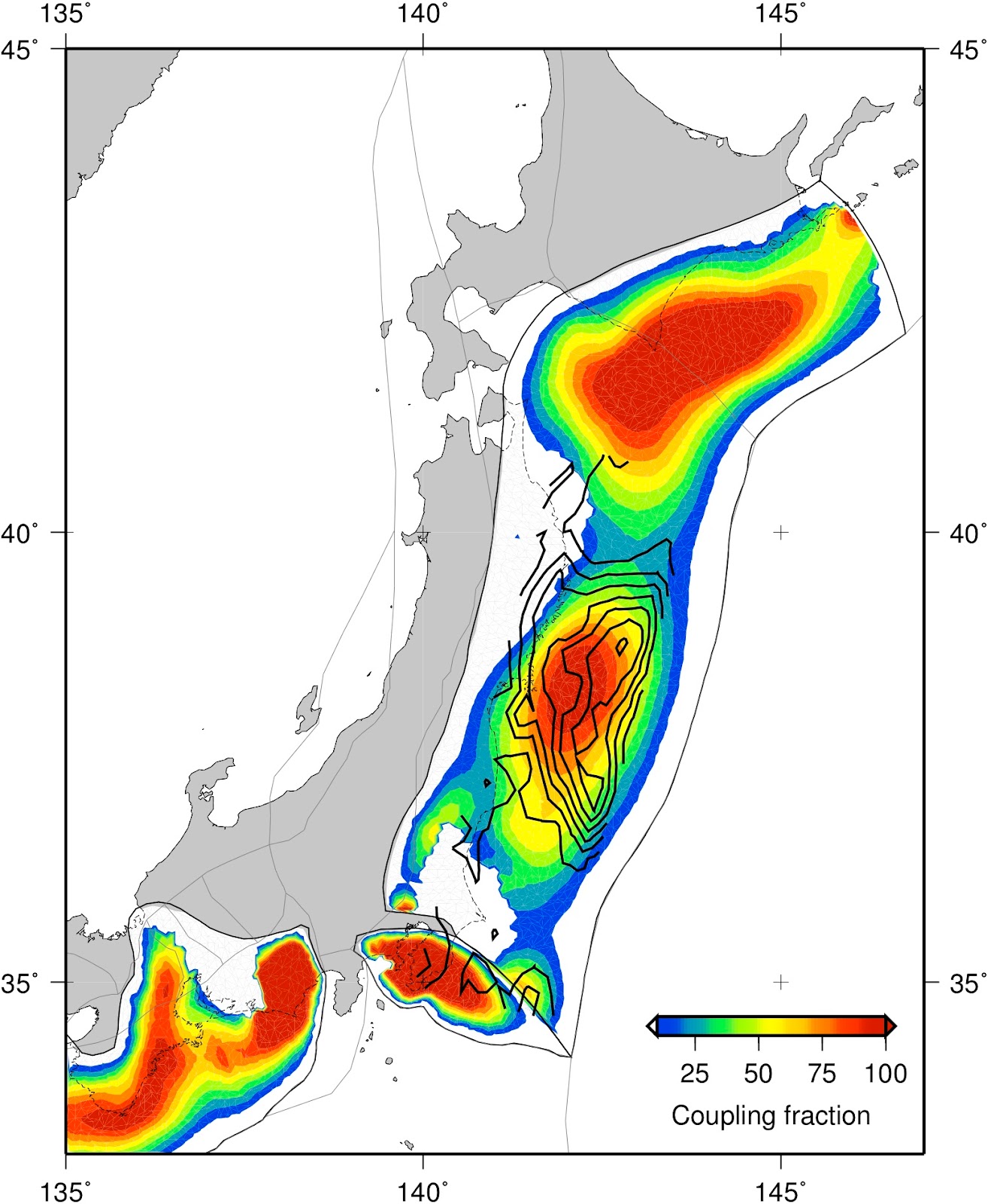
INTERSEISMIC COUPLING distribution based on GEONET GPS data from 1996-2000 and estimated using a three-dimensional block model of the combined offshore/onshore fault network (Loveless and Meade, JGR, 2010) . Coupling was estimated on a mesh of triangular dislocation elements based on 3D slab geometry.


COSEISMIC DISPLACEMENT - HORIZONTAL AND VERTICAL displacements based on estimated position of GEONET stations. Coseismic displacement is shown in red, and first 8 hours of postseismic displacement at available stations is shown in blue. Bars at end of vector show 95% error estimate. Solutions courtesy of ARIA team at JPL and Caltech. Preliminary computation shows a horizontal displacement of ~2.4 mts (USGS, Kenneth).

Slip distribution on a curved plate interface using coseismic GPS vectors from the Geospatial Information Authority of Japan. The above plot shows the slip distribution, which extends about 400km N-S and reaches a maximum of about 10 meters. (Ito, Ozawa, Watanabe and Sagiya from Nagoya University)

High-rate 1-Hz data from one station of the International GNSS Service affected by the Sendai earthquake. The record is from the MIZU station located at Mizusawa. The analysis approach uses PPP or precise point positioning, a technique that requires meticulous modeling of all of the phenomena affecting GPS measurements to reveal station displacements with precisions approaching a few centimetres. (Banville and Langley from University of New Brunswick)
No hay comentarios:
Publicar un comentario